


The Secret Signal
The Semaphore Towers of the Hudson

A new episode of the Restoration Obscura Field Guide Podcast is coming soon, streaming on all major platforms and at www.restorationobscura.com.
Before electricity. Before Morse. Before wires stitched the world together. There was a language made of angles and light. High above the Hudson River, from Mount Beacon to Breakneck Ridge, wooden towers stood silent watch, relaying messages at the speed of sight. This was semaphore, an optical telegraph powered by clarity alone. Hinged arms formed codes. Operators scanned horizons. And for a brief moment in the early 19th century, as the War of 1812 stirred fears of British invasion along the coast and inland waterways, the Hudson Valley carried signals visible only to those who knew where and how to look. The towers are gone. The wood is gone. What remains is the logic they followed and the names still written across the land. This is the story of a system meant to vanish, and the brief life of a signal that once traveled the sky by sight alone.
Long before wires carried signals and codes across continents, messages once followed the shape of the land, few places reveal that better than the Hudson River Valley. Here, the hills themselves once served as silent conduits of communication. From the high ridges above Newburgh to the fire-beaconed slopes of Mount Beacon, the Hudson’s geography offered a natural stage for a vanished system: the semaphore telegraph.
This was a different kind of message. It moved at the speed of sight. It relied on distance, clarity, and the steadiness of human hands. Skies had to be clear. Operators had to know their angles. What mattered was elevation and visibility—not buried infrastructure or voltage.
Messages crested ridgelines, stretched across river valleys, and crossed vast terrain one relay at a time. Tower to tower, signal points rose like punctuation marks in the landscape. These were not shelters or destinations. They were built to be seen.
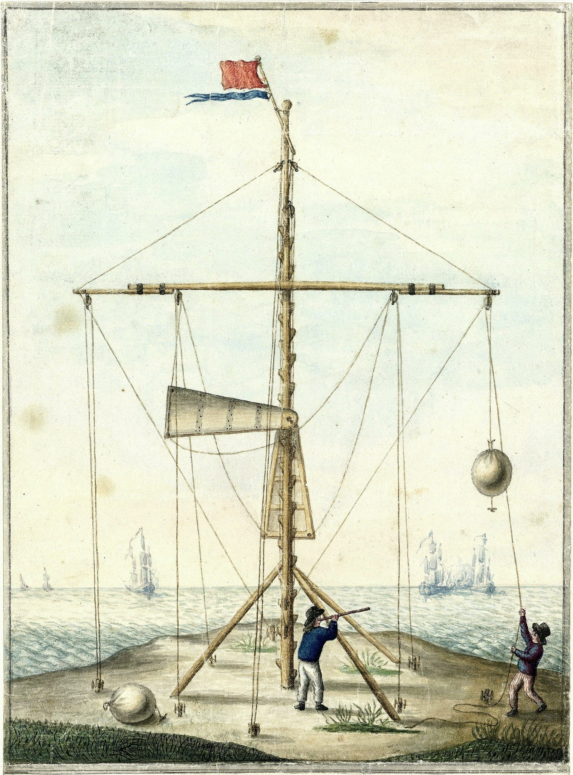
At the top of each structure stood a mast, often flanked by jointed arms mounted on crossbeams. These arms could be positioned into a series of angles that, when viewed from a distance, formed symbols tied to a specific codebook. A typical configuration included a tall central shaft with two horizontal arms, each hinged at two or three points, allowing for dozens of variations. Some systems used stark paint colors for visibility. Others relied on shape alone. When arranged correctly, a single position could represent a letter, number, or predefined phrase.
Operators stationed at each tower observed neighboring stations through telescopes or viewing hoods, recorded the position of the arms, then manually set their own tower’s signal to match. The message moved from tower to tower in this way, sometimes covering hundreds of miles. In good weather, it could travel faster than any horse or steamboat—crossing entire regions before the hour was up.
But who were these operators?
They were not soldiers, at least not always. In France and Britain, many were trained civil servants or local residents contracted by the state. Others were ex-military, chosen for their discipline and visual acuity. Operators needed more than just steady hands—they required mathematical precision, fluency in code, and the ability to remain focused for hours while scanning distant hills through glass and glare. Some were posted in pairs; others worked alone. In France, the position was considered prestigious. In Britain, it was often a naval assignment. In either case, these were people who trained to think in symbols and act without hesitation. A single misread position could alter the meaning of a sentence or scramble an entire message chain.
These were the semaphore telegraphs. Mechanical, temporary, and demanding. They transmitted nothing but form. No voice. No current. What they required was precision. Each gesture had to be correct. Each pause understood. Meaning lived in the angles—where the arms pointed, how long they held, how quickly they changed.
They operated without wires or electricity. They left little behind. The only sound was wind through timber and the scrape of gears as an operator worked the cranks and pulleys. Each tower was both a terminus and a bridge, standing still while meaning passed through it like light through glass. In a world that still moved by sail and hoof, semaphore promised something radical: that a thought could travel faster than the person who spoke it.
Its tactical advantages were equally radical. Semaphore was faster than a dispatch rider and far less vulnerable to interception than a written courier. No physical documents were carried, nothing to be captured or copied—just patterns of movement. Because it required elevation and clear line-of-sight, it favored high ground already defensible by nature. And unlike beacon fires, which could convey only general alerts, semaphore allowed for full sentences, names, coordinates, and encoded detail. It was real-time communication in an era otherwise starved for immediacy.
In a military context, this meant commanders could react to enemy movement while it was still unfolding. Orders could be updated. Warnings issued. Supplies redirected. Armies could coordinate over vast distances without relying on the uncertain rhythm of hoofbeats and tide. Even in peacetime, semaphore granted governments a new level of logistical control—whether moving troops, managing coastal defenses, or relaying political developments across provinces.
But they were not built to last. Wooden frames warped in rain and cracked in frost. Paint peeled. Pulleys rusted. Fog stopped them completely. Yet despite their fragility, they were revolutionary. They required no fuel, only high ground and clear skies. With a pair of arms and a practiced crew, they compressed geography into signal.
Semaphore belonged to a narrow chapter in communication history—a fleeting era between beacon fires and copper wire. Too complex for bonfires. Too exposed to outlast Morse. But for a time, sight became strategy.
In the 1790s, Claude Chappe formalized the system in revolutionary France. His towers, spaced roughly ten kilometers apart, stretched from Paris to Lille and beyond. Each featured a large central beam known as a regulator, with two smaller indicators at either end. Together, they could form nearly 200 configurations, each linked to an alphanumeric codebook. Chappe’s system was astonishingly fast. Messages that once took days by courier could now travel across the country in under an hour. His operators were drawn from educated, literate classes—often men with mathematical or technical training, many of whom were loyal to the revolutionary government. Their work was considered part of the national defense apparatus.
Britain developed its own network using shutter panels. The Royal Navy employed visual telegraph lines to transmit news between ports and the Admiralty in London. From Portsmouth to Deal to Plymouth, signal stations dotted the coast, relaying commands and confirming sightings. These operators were often enlisted sailors or retired officers with technical experience, stationed at outposts designed for clear visibility and fast response. On clear days, a message could cross southern England in under twenty minutes. These were not experiments. They were operational defense infrastructure—designed for speed, secrecy, and survival.
Semaphore had limits. Fog silenced it. Snow concealed it. Enemies could observe it. Messages could only be sent in daylight. Terrain dictated routes. The labor was constant. Crews required training. Codebooks demanded memorization. Accuracy took discipline. But in an age of slow ships and uncertain roads, semaphore offered something new: near-instant information. And in that narrow window of technological evolution, speed equaled power.
In the United States, where terrain was often rugged and infrastructure scarce, semaphore never reached the scale it did in Europe. But it existed. And it mattered. In 1813, during the War of 1812, Irish-born engineer Christopher Colles designed a semaphore line between New York City and Sandy Hook, New Jersey, to warn of British ships. His system used a combination of moving arms and numerical dials, manually operated to transmit coded messages across 47 miles of coastline. Though short-lived, the project proved that visual signaling could work in American conditions.
Colles himself was a polymath—an engineer, cartographer, and inventor who had previously proposed waterworks, roads, and navigation projects for New York State. His semaphore towers were likely manned by local volunteers or militia members trained in the codebook. These were ad hoc installations, improvised in times of threat and removed when the danger passed.
Which brings us again to the Hudson.
The Hudson River has always been more than water. It is a corridor of commerce, a defensive spine, a stage for revolution. The steep hills along its banks are natural lookouts. During the Revolutionary War, signal fires burned from the Palisades to Mount Beacon. Smoke by day, fire by night. A language older than code.
By the early 19th century, as the country once again braced for conflict, planners turned back to those same ridgelines. The War of 1812 had raised serious concerns about British naval attacks along the Atlantic coast and possible incursions up the Hudson River, a vital corridor linking New York City to the interior. In response, military and civilian leaders explored ways to modernize early warning systems beyond the traditional beacon fires used during the Revolution. Proposals circulated for visual signaling networks between New York City and Albany, modeled in part on European semaphore systems then in use. While definitive maps are lacking, circumstantial evidence remains. Place names like Telegraph Road, Signal Hill, and Beacon Mountain appear across the Hudson Valley. These are not just poetic names, they likely reference real infrastructure, though direct links to semaphore use are difficult to confirm.
From Breakneck Ridge to Storm King and the highlands of Columbia County, the topography suggests a natural line-of-sight corridor. On clear days, observers at Mount Beacon can see for miles. These peaks were not chosen at random. They were chosen because they could see.
Mount Beacon itself was named for its wartime signaling role. Later, it hosted radar installations, weather instruments, and broadcast towers. It’s reasonable to believe it may have served as a relay point during the semaphore era as well, though no formal record of such a system survives.
By the 1830s and 1840s, with steamboats dominating the Hudson, another layer of signaling emerged. Paddlewheelers like the Albany and the Hendrick Hudson raced between landings. Signal flags, towers, and watch stations on shore relayed their progress. Even after the electric telegraph arrived, visual signals were used by lock tenders, depot agents, and canal workers to coordinate movements.
Whether a full semaphore chain was ever completed along the Hudson is uncertain. Colles’s coastal system is better documented. But inland, temporary and informal signal posts likely reused Revolutionary-era fire stations—wooden platforms, signal flags, and hinged arms, quickly deployed and just as quickly removed when peace returned.
The electric telegraph rendered semaphore obsolete almost overnight. In 1844, when Samuel Morse sent the first message between Washington and Baltimore, the world changed. Wires didn’t care about hills. Messages no longer needed light or line of sight. By the 1850s, semaphore towers across Europe and the Americas were dismantled, their wood reused, their operators reassigned, their codebooks shelved.
Stand atop Mount Beacon and look west. From this vantage, you can see Butter Hill, Storm King, and the ridge above Newburgh, all prominent elevations with uninterrupted sightlines. The view extends deep into the Hudson Highlands and, on clear days, toward the distant silhouettes of the Catskills. These ridgelines weren’t chosen for aesthetics; they were selected for what they offered tactically: visibility, elevation, and continuity. The geography itself suggests a corridor of communication. Whether used for beacon fires, flag relays, or semaphore arms, these high points formed a logical chain, natural platforms from which information could travel by sight, one signal at a time.
Nothing of the towers remains. No stone footings. No gears. But the names remain. The elevations remain. The logic remains.
This was a language without sound. A system built to vanish. That is what makes it so distinctly Restoration Obscura, a signal meant to be seen, then gone. Semaphore left almost no trace.
It was never meant to last. It was meant to serve a moment, and for a brief and brilliant time, it did.
About Restoration Obscura
Restoration Obscura is where overlooked history gets another shot at being seen, heard, and understood. Through long-form storytelling, archival research, and photographic restoration, we recover the forgotten chapters—the ones buried in basements, fading in family albums, or sealed behind locked doors.
The name nods to the camera obscura, an early photographic device that captured light in a darkened chamber. Restoration Obscura flips that idea, pulling stories out of darkness and casting light on what history left behind.
This project uncovers what textbooks miss: Cold War secrets, vanished neighborhoods, wartime experiments, strange ruins, lost towns, and the people tied to them. Each episode, article, or image rebuilds a fractured past and brings it back into focus, one story at a time.
If you believe memory is worth preserving, if you’ve ever felt something standing at the edge of a ruin or holding an old photograph, this space is for you.
Subscribe to support independent, reader-funded storytelling: www.restorationobscura.com
🎧 The Restoration Obscura Field Guide Podcast is streaming now on all major streaming platforms.
Every photo has a story. And every story connects us.
© 2025 John Bulmer Media & Restoration Obscura. All rights reserved. Educational use only.
Permissions Statement
Restoration Obscura may not hold copyright for all images featured in its archives or publications. For uses beyond educational or non-commercial purposes, please contact the institution or original source that provided the image.