

Erasing Neversink
The Taking of Neversink and Bittersweet


Restoration Obscura documents overlooked histories through fieldwork, archival research, and photographic restoration. Subscribe for monthly investigations at the intersection of documentary journalism and historical preservation.
Briefing Note: This is a longform Restoration Obscura feature.
If you are receiving this article in your inbox, your email client may clip or truncate the content due to its length. You can always read the complete version directly on Restoration Obscura, where the full text is presented without interruption.
Restoration Obscura articles are written works intended to be read as text. Substack may automatically generate an AI-based audio narration of this article within the Substack app. Pronunciations of certain place names, personal names, and historical references in these auto-generated narrations may be inaccurate. The written version should be considered the authoritative source.
The Neversink Reservoir was not built on empty land. It was created through a coordinated campaign of eminent domain, demolition, and relocation that removed entire communities to secure water for New York City. The hamlets of Bittersweet and Old Neversink were dismantled while still alive, their buildings razed, their cemeteries opened, and their residents pushed uphill or out of the valley altogether. What remains today appears as quiet Catskill wilderness, yet the landscape is engineered and intentional. Beneath the reservoir’s surface lie the physical remains of towns sacrificed for urban growth, along with the stories of the families and workers whose lives were disrupted or lost in the process.
The water that flows from Manhattan taps carries a difficult history. Somewhere beneath 175 feet of reservoir, in the dark where the Neversink River once ran through Sullivan County, lie the foundations of two hamlets the city dismantled by design. Bittersweet and Old Neversink existed for more than a century before the City of New York decided they would cease to exist at all.
This is not a story of decline. The communities that vanished under the Neversink Reservoir in 1953 were still functioning. Schools, churches, a post office dating to 1828, a covered bridge that crossed water now impounded above it. The erasure was total: administrative, legal, and coordinated. The affected populations called it, simply, “The Taking.”
The Machinery of Displacement
The legal architecture that enabled New York City to drown the Neversink Valley was decades in the making. The Acts of 1905 authorized the city to condemn land for water supply purposes, establishing eminent domain as the primary mechanism of acquisition. A 1931 Supreme Court ruling granted the city rights to divert 440 million gallons daily from the Delaware River system, provided it maintained downstream flow requirements. By 1941, when construction began, the legal groundwork was complete. What remained was execution.
The bureaucratic structure of land acquisition was designed to minimize compensation while maximizing administrative expenditure. A 1906 amendment required the city to pay only half the assessed value of condemned land before taking possession. Families who had held property for generations found themselves ousted for sums as low as $250, valuations that bore no relationship to the land’s utility, history, or meaning to those who lived on it.
For every dollar paid in compensation, the commissions responsible for appraisals and acquisitions spent more than fifty-four cents on administrative expenses. Commissioners drew $50 per day plus expenses. Appraisal witnesses received between $10 and $50 daily. The machinery of displacement enriched its operators while impoverishing its victims. Local residents perceived this disparity clearly: the city would spend lavishly on the apparatus of removal while bargaining aggressively to minimize payments to those being removed.
The word “take” persisted in local usage for decades afterward. Not “purchase,” not “acquire,” not “condemn,” but “take,” a term that preserved the coercive reality beneath the legal formalism.
The Lost
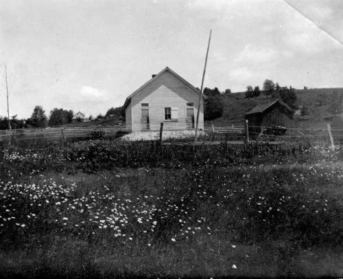
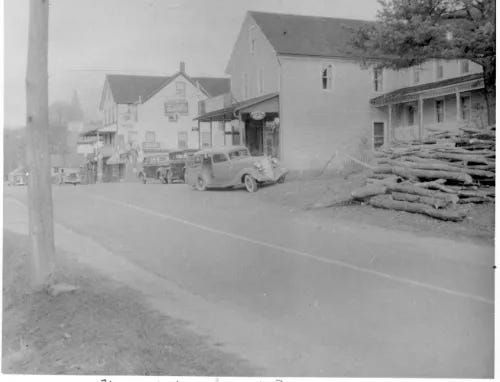
Old Neversink, founded in 1798, functioned as the valley’s civic center. Its main street ran parallel to the river. A covered bridge connected the community across the Neversink. A Methodist chapel anchored the settlement’s spiritual life. The two-room district schoolhouse served families whose children would become the last generation to know the valley floor. A post office had operated continuously since April 25, 1828, when Richard D. Childs became its first postmaster. By the time construction began, the community had survived the collapse of the regional tanning industry and adapted to an economy centered on agriculture, tourism, and small-scale commerce.
Bittersweet was smaller, named for the climbing plant Celastrus scandens that grew in profusion along the valley. Its post office opened on Christmas Eve, 1915, with Henry J. Sackett as postmaster. The name became prophetic: sweet for the urbanites who received the water, bitter for those who lost their heritage. Unlike Old Neversink, where a remnant of identity survived through relocation of the town center to Route 55, Bittersweet was erased entirely. No relocation. No remnant. The settlement became, in the regional phrase, “another Catskill Mountains Atlantis.”
Topographic mapping from 1947, just before the final stages of construction, identified 116 buildings for destruction. Seventy-six would be submerged entirely. Forty more stood on land designated for watershed protection. The inventory included four churches and four schools: the total social and spiritual infrastructure of the valley floor.
The Final Harvest
The most harrowing dimension of the Neversink project was the mass disinterment of human remains. The 1905 legislation that authorized land acquisition also mandated removal and re-interment of bodies found within reservoir footprints. Across the entire Catskill-Delaware system, the city recovered 8,093 bodies from 57 cemeteries. For the Neversink Reservoir specifically, 2,369 graves required relocation: at least one major cemetery, along with numerous smaller family burial plots scattered across the valley floor.
The process was managed by the Army Corps of Engineers and private contractors. Each grave was documented. Remains were disinterred and placed in new pine boxes along with any artifacts, metal casket remnants, or personal possessions recovered from the soil. These were then transported to new burial sites outside the inundation zone: Grahamsville Rural Cemetery, Hodge Cemetery in Aden, and other locations where the displaced dead could be deposited beyond the waterline.
For many families, this was a second displacement. The eternal rest of ancestors was interrupted by the same bureaucratic apparatus that had evicted the living. While relatives could reclaim remains for private re-interment, the majority were moved by city contractors to designated plots. In cases of older or unmarked graves, and there were many, identities were lost during the process.
Photographs of the new cemetery sites show rows of wooden markers bearing only the word “unknown.” People whose names survived in local memory for generations were rendered anonymous by the administrative machinery of displacement.
In some regional cases, the new burial sites were so rocky that contractors required jackhammers and dynamite to prepare the graves. The image compounds the violation: the state blasting through stone to deposit remains it had already uprooted once.
This is the unspoken history of reservoirs everywhere. The calm surface, the morning mist rising off the water, the kayakers and fishermen who come for the stillness: all of it rests on cleared ground. Somewhere beneath that stillness, in nearly every impoundment of this scale, homes were demolished and graves were opened. Foundations were filled and the dead were boxed and trucked to higher ground so that water could collect where lives had been lived. The people who drink from these systems, sometimes hundreds of miles away, rarely consider what was removed to fill their glasses. The reservoir presents as nature. It is not. It is an engineered silence, and beneath that silence lie the stones of churches, the bones of the relocated dead, and the memory of communities that existed until someone decided they would not.
The Segregated City Below the Dam
The displacement of original inhabitants made way for a temporary, transient population: the reservoir workforce. At peak construction, the project employed thousands of laborers housed in work camps that functioned as miniature cities. These facilities accommodated up to 2,500 workers and were equipped with hospitals, fire departments, sewage systems, and retail stores. They were also segregated, policed, and lethal.
The demographic composition reflected mid-century American labor patterns. Workers were drawn primarily from recent immigrant populations: Irish, Italian, Eastern European, many recruited directly from steamship docks in New York City. African Americans who had participated in the Great Migration northward filled out the ranks. The internal organization of the camps, however, mirrored the racial and ethnic segregation of the era. Italian and Black workers occupied separate quarters below the dam while white Americans lived apart. This spatial division served institutional purposes: it prevented the formation of broad labor solidarity and managed friction between the transient workforce and the local population, which was largely descended from English and Dutch settlers and viewed the new arrivals with considerable prejudice.
The Neversink Dam was among the last of the “handmade dams,” built through brute force, manual labor, and early-stage explosives rather than the diesel-powered machinery that would characterize later projects. Workers moved massive amounts of muck and stone using mules and dynamite. The instability of core walls and primitive scaffolding created conditions where death was routine. Approximately one-tenth of the workforce was killed or injured annually. Across the broader Catskill-Delaware system, more than 3,800 serious accidents were recorded.
The deaths had names. During the construction of the core wall, the forms collapsed and sent Albert “Mike” Kortright, twenty-two years old, Werner Gills, thirty, and Lee Bridges, fifty-three, falling fifty feet to the ground. They did not survive. The invisibility of these losses was facilitated by the social status of the victims. The deaths of “inconspicuous” laborers, foreign-born or Black, attracted minimal public attention compared to the engineering marvel they were building.
A specialized segment of the workforce, the sandhogs, tunneled through bedrock and excavated caissons under compressed air. These urban miners worked in 80-degree temperatures inside the caissons, facing constant threat of cave-ins and the debilitating risk of decompression sickness, known as “the bends.” Exposure to dust from tunnel boring machines produced silicosis over time. The psychological toll of working in coffin-like airlocks contributed to turnover rates that saw up to 100 men quit per week on the most dangerous excavation projects.
Violence and destruction extended beyond human mortality. On January 21, 1951, a massive fire broke out at the dam site, targeting a warehouse owned by the S.A. Healy Company, the principal contractor. The fire caused over a million dollars in damage, destroying expensive equipment and massive tires weighing 1,800 pounds each. While official reports attributed the blaze to accident or mechanical failure, such events occurred within a broader context of labor tension that characterized large-scale industrial projects of the era.
To maintain order within the volatile camps, the City of New York deployed the Board of Water Supply Police, a specialized force created through amendments to the 1905 Water Supply Act. At their peak, 377 mounted patrolmen operated across the reservoir and aqueduct sites. Their mandate was to prevent labor unrest, manage friction between workers and locals, and enforce discipline in the camps. In their busiest year, patrolmen arrested over 1,500 people. Across the construction of the Catskill-Delaware system, their testimony resulted in more than 5,000 convictions and seven executions.
Most arrests occurred in high-tension zones along the aqueduct and dam sites, where working conditions were most dangerous and the concentration of immigrant and Black laborers was highest. The BWS Police regulated prostitution, gambling, alcohol, and disorderly conduct with paramilitary efficiency. They functioned as an arm of the city, ensuring the construction timeline was not disrupted by the social realities of the camps.
The presence of this force created significant tension with permanent residents of Sullivan County. These officers were seen as city interlopers who enforced New York’s will on a population already reeling from the loss of their land. The BWS Police followed methods and laws prescribed by city officials rather than those of neighboring towns. Locals found themselves caught between the transient workforce they feared and the city-funded police force they resented.
Workers organized strikes for better wages. Displaced residents formed coalitions to fight for fair compensation. The camps produced dangerous social environments and dangerous men who challenged the city’s authority. But the dam rose anyway. When it was completed in 1953, the camps vanished as quickly as they had appeared. The workers dispersed. The police withdrew. What remained was the water, and beneath it, the ruins.
The False Wilderness
Today, the Neversink Watershed presents as pristine Catskill landscape. The New York City Department of Environmental Protection continues acquiring land to prevent pollution and protect water quality. Large tracts of forest have been preserved.The appearance suggests wilderness. The record shows something else.
Beneath the forest canopy lie the foundations, stone walls, and wells of the former communities. These ruins serve as persistent evidence that the “pristine” environment of the Catskills is an anthropogenic creation, a managed ecosystem necessitated by the displacement of its original human occupants. The wilderness is not natural but produced, and its production required erasure.
The demographic shifts in the decades since completion have been pronounced. Research indicates watershed communities now have significantly higher proportions of retirees and higher median ages than neighboring areas. Younger individuals leave for education and employment opportunities unavailable in a region whose economic base was dismantled by eminent domain. Traditional professions in agriculture and industry have struggled to survive. Farms face foreclosure or transition to non-agricultural uses as younger generations show little interest in working land that might be condemned next.
This “aging of the watershed” threatens long-term regional vitality. A demographic deficit has emerged: too few young people to sustain communities, too many aging residents dependent on services that declining tax bases cannot support.
The DEP projects acquiring another 137,000 acres around Catskill reservoirs by 2034. The erasure continues.
Legacy
The Time and the Valleys Museum in Grahamsville serves as the primary repository for oral histories, photographs, and artifacts of the lost communities. Exhibits like “Bittersweet Memories: Lost Towns of the Catskills Watersheds” and “Tunnels, Toil and Trouble” help visitors visualize submerged hamlets and connect with personal stories of those who were forced to leave, and those who died building what replaced them.
Town historians continue assisting descendants in researching family trees and cemetery records, providing vital links to a past that was physically erased by rising waters. The Local History Research Center houses hundreds of books, ledgers, and photographs documenting the Towns of Neversink and Denning. Personal narratives, such as those of the Kortright family, help humanize the statistics of industrial mortality.
Resentment toward New York City persists among contemporary locals, many of whom harbor grudges passed down through generations. The city remains an intruder in local political and community affairs, particularly as the DEP continues its land acquisition programs. This tension is the direct inheritance of initial displacement: low compensation, bureaucratic inefficiency, radical erasure of cultural heritage, and the deaths of workers whose sacrifices remain largely unacknowledged.
During severe droughts, the reservoir level drops enough to expose remnants of the submerged settlements. The steeple of the old Methodist chapel becomes briefly visible. Stone foundations emerge from the mud. For a few weeks, the false wilderness reveals what it conceals, and then the waters rise again, and the ruins return to darkness.
The Neversink Reservoir holds 34.9 billion gallons and provides water to millions. The Neversink Tunnel, a six-mile engineering marvel, allows this water to flow by gravity to the Rondout Reservoir and into the Delaware Aqueduct. By any technical measure, the project succeeded.
The town of Neversink remained “dry,” prohibiting alcohol sales, from the 1930s until 2015, a cultural vestige of the era when the community fought to maintain traditional values against urban encroachment. The prohibition outlasted the valley it was meant to protect by more than sixty years.
Coda: The Architecture of Erasure
The displacement of the Neversink populations was not exceptional. It was systematic, one component of a larger program that sacrificed rural communities throughout the Catskills for metropolitan water needs. The legal mechanisms, bureaucratic structures, and physical processes deployed against Bittersweet and Old Neversink were refined through repetition across dozens of sites.
What distinguishes the Neversink case is not its uniqueness but its typicality. The hamlets that drowned there were destroyed by the same apparatus that destroyed hamlets elsewhere, using the same legal authorities, the same administrative procedures, the same clinical efficiency. The taking was institutional violence, impersonal and reproducible.
The water that reaches Manhattan carries no trace of origin. It arrives through pipes, emerges from faucets, and is consumed without thought for the valley floors that were cleared to hold it, or the workers who died clearing them. The Neversink Reservoir is a landscape of profound silence, a false wilderness where the ruins of a vibrant community lie beneath 175 feet of water, a permanent monument to the human cost of urban expansion.
The name Bittersweet was always prophetic. The climbing plant still grows in the Catskills, its orange and red berries brightening autumn hillsides above the waterline. Below the surface, in the perpetual dark of the reservoir floor, the foundations of the hamlet that bore its name remain exactly where they were left: unmoved, unnamed, and slowly being forgotten.
Field research for this article was conducted in Sullivan County, New York. Archival materials were accessed through the Time and the Valleys Museum Local History Research Center in Grahamsville. The author gratefully acknowledges the assistance of town historians and the descendants of displaced families who shared their oral histories.
RESTORATION OBSCURA DOCUMENTATION CODEX
ERASING NEVERSINK: The Taking of Neversink and Bittersweet
The following Documentation Codex accompanies this field report and serves as a permanent archival reference.
Restoration Obscura Documentation Codex: Mission Statement
The Documentation Codex provides a standardized framework for preserving, organizing, and interpreting historical material. Its purpose is to collect primary sources, field observations, photographic records, and verified archival references into a coherent system that supports clear, accurate, and transparent historical analysis.
Each codex entry is assembled with a commitment to evidence-based research. Provenance is documented in full, interpretive boundaries are clearly defined, and all materials are presented in a format that can be revisited, verified, and expanded as new information or scholarship emerges. The Codex is intentionally designed to aid future researchers who wish to deepen or reexamine the subject of each article.
Ultimately, the Codex exists to safeguard vulnerable histories, illuminate overlooked narratives, and connect readers with the physical and cultural landscapes that shaped their communities. It reflects Restoration Obscura’s central belief that responsible storytelling begins with rigorous documentation and continues through the ongoing return of knowledge to the public.
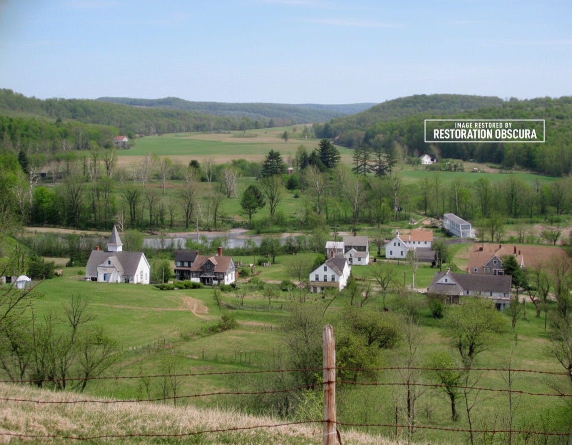
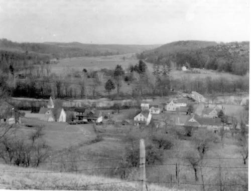
Original Neversink Valley Photo, Circa 1900
Principal Figures and Biographical Vectors
Richard D. Childs
First postmaster of Old Neversink, appointed April 25, 1828. His tenure marks the formal federal recognition of the hamlet as a functioning civic center. The establishment of the post office indicates the maturity of the settlement and its integration into regional trade and communication networks.
Henry J. Sackett
Postmaster of Bittersweet, appointed December 24, 1915. His service reflects the continued viability of small rural postal communities into the early twentieth century, prior to the watershed condemnations.
Albert “Mike” Kortright (1928–1950)
Construction laborer killed during collapse of the dam core wall forms. His death represents the human toll among the reservoir workforce and serves as a documented case within the broader pattern of industrial casualties during Catskill water system construction.
Werner Gills (1920–1950)
Construction laborer killed alongside Kortright during the core wall collapse. His presence reflects the immigrant labor demographics typical of mid century infrastructure projects.
Lee Bridges (1897–1950)
Older laborer killed in the same incident. His death reflects the multi generational composition of the workforce, which included both young migrant workers and older men seeking employment during postwar construction booms.
Secondary Figures and Political Networks
Board of Water Supply Commissioners
Appointed officials responsible for condemnation proceedings, appraisal oversight, and compensation structures. Their administrative role shaped the economic outcome for displaced families.
New York City Board of Water Supply Police
Paramilitary enforcement body created under amendments to the 1905 Water Supply Act. Tasked with maintaining order in construction camps and along aqueduct corridors. Their activities reflect the extension of municipal authority into rural counties.
S. A. Healy Company
Principal contractor for the Neversink Dam project. Their facilities and equipment were central to the construction effort, including the warehouse destroyed in the January 1951 fire.
Army Corps of Engineers
Oversaw the disinterment and relocation of cemetery remains. Their involvement formalized the federal role in the physical clearing of reservoir footprints.
Structures, Sites, and Geographical Coordinates
Old Neversink Hamlet Site
Approximate center: 41.882° N, 74.563° W
Former civic nucleus of the valley, including post office, schoolhouse, chapel, and covered bridge. Submerged beneath the Neversink Reservoir following dam completion in 1953.
Bittersweet Hamlet Site
Approximate location: within the central basin of the reservoir, south of Old Neversink’s former alignment.
Smaller settlement erased without relocation or preservation of civic identity.
Neversink Dam
41.873° N, 74.587° W
Completed 1953. One of the last large American dams constructed primarily through manual labor and early explosives.
Grahamsville Rural Cemetery
41.854° N, 74.557° W
Primary reinterment site for remains disinterred from valley cemeteries.
Hodge Cemetery, Aden
Secondary relocation site for displaced graves.
Neversink Tunnel
Six mile gravity conduit linking Neversink Reservoir to Rondout Reservoir. Key component of the Delaware Aqueduct system.
Thematic Record Groups
RG 1: Legal Instruments of Condemnation
Acts of 1905, subsequent amendments, and the 1931 Supreme Court ruling authorizing diversion from the Delaware system.
RG 2: Land Acquisition and Compensation Files
Appraisal records, commissioner reports, and compensation disputes documenting the economic impact of displacement.
RG 3: Community Infrastructure and Social Fabric
Schools, churches, post offices, bridges, and agricultural holdings of the valley settlements.
RG 4: Cemetery Removal and Reinterment Operations
Documentation of grave relocations, contractor reports, and cemetery inventories.
RG 5: Construction Camp Life and Labor Conditions
Records of workforce demographics, accidents, strikes, segregation policies, and policing.
RG 6: Post Inundation Demographic and Economic Changes
Population age shifts, agricultural decline, and ongoing land acquisition policies.
Event Chronologies and Timeline Index
1798
Founding of Old Neversink.
1828
Old Neversink post office established.
1905
Water Supply Acts authorize condemnation for reservoir construction.
1906
Amendment permits possession after payment of half assessed land value.
1915
Bittersweet post office established.
1931
Supreme Court ruling authorizes diversion of 440 million gallons daily.
1941
Construction of Neversink Dam begins.
1947
Topographic mapping identifies 116 buildings slated for removal.
1950
Core wall collapse kills Kortright, Gills, and Bridges.
January 21, 1951
Major fire destroys contractor warehouse.
1953
Completion of Neversink Dam. Valley inundated.
2015
Town of Neversink repeals local prohibition laws.
Searchable Terms and Controlled Vocabulary
Catskill Mountains watershed districts
Neversink Valley agricultural settlements
Eminent domain proceedings, New York State
Rural displacement, twentieth century
Reservoir construction labor camps
Cemetery relocation operations
Board of Water Supply policing records
Industrial accident registers, dam construction
Catskill–Delaware water supply system
Submerged settlements, Sullivan County
Hydraulic infrastructure and demographic change
Archival Holdings and Publisher Information
Restoration Obscura Field Documentation Series
Codex Reference: RO–NV–1953–ERASURE
Field Research Period: 2025–2026
Primary Location: Sullivan County, New York
Custodial Notes
Oral histories, photographic references, and cemetery records consulted at the Time and the Valleys Museum Local History Research Center, Grahamsville, New York.
Publisher
Restoration Obscura Press
Albany, New York
Independent documentary and historical field research imprint.
Accession Notes
Digital field files, restoration images, and interview transcripts retained in the Restoration Obscura primary archive under series NV–ERASURE.
Works Cited
Time and the Valleys Museum, Grahamsville, New York.
Town of Neversink Historical Records.New York City Department of Environmental Protection Archives.
U.S. Army Corps of Engineers Project Documentation.
Sullivan County Historical Society Collections.
Catskill Watershed Corporation Publications.
Board of Water Supply Police Records.
S. A. Healy Company Project Documentation.
New York State Water Supply Commission Reports, 1905–1953.
Delaware Aqueduct Planning and Engineering Reports.
Local cemetery relocation registers, Grahamsville Rural Cemetery.
Oral history transcripts, Neversink Valley descendants.
Keywords
Neversink Reservoir
Old Neversink
Bittersweet hamlet
Catskill water system
Eminent domain
New York City watershed
Reservoir displacement
Sullivan County history
Submerged towns
Cemetery relocation
Dam construction labor
Board of Water Supply
Catskill–Delaware aqueduct
Rural community erasure
Watershed demographics
Neversink Dam construction
Industrial accidents
Mid century infrastructure
Catskill valley settlements
Restoration Obscura Codex
Official Restoration Obscura Field Gear
The Restoration Obscura Shop offers official apparel and accessories featuring designs inspired by the stories, books, and podcasts from the world of Restoration Obscura. Each item is available in men’s and women’s styles with multiple color options, printed on demand through trusted partners. Built for everyday wear and ready for a day in the field, our shirts, hoodies, hats, mugs, and stickers are available now and ready to ship.

Now Available from Restoration Obscura Press
Field Guide to the Night
by John Bulmer
Night has always been our oldest frontier.
From the first skywatchers charting constellations to the blacked-out cities of wartime and the quiet hum of Cold War surveillance, Field Guide to the Night follows humanity’s shifting relationship with darkness. Through history, science, and story, John Bulmer explores how the absence of light has shaped memory, faith, and fear, and how our modern brilliance has obscured the world our ancestors once knew by instinct.
Part cultural history, part personal exploration, Field Guide to the Night invites readers to look beyond the city’s glow, to rediscover what survives in the unlit hours, and to understand how night continues to define what it means to be human.
Paperback $14.99 | Kindle $9.99
368 pages | ISBN 979-8218702731
Published June 1, 2025 by Restoration Obscura Press
Available worldwide on Amazon.
About Restoration Obscura
Restoration Obscura recovers histories that slipped through the official record. Through long-form storytelling, archival research, photographic restoration, and field investigations, we bring forgotten narratives back into view. The project works where memory, landscape, and culture meet: Cold War infrastructure, lost towns, vanished neighborhoods, industrial ruins, environmental history, and the overlooked lives threaded through them. Each story rebuilds fragments of the past and carries them forward.
The Restoration Obscura Field Guide Podcast streams on all major platforms. Every photo has a story. Every story connects us.
Subscribe to support reader-funded investigative history at restorationobscura.com
Provenance and Restoration Statement
Restoration Obscura draws from public archives, institutional collections, private holdings, and family materials. Some images and documents have incomplete or uncertain provenance. When known, all sources are credited.
Visual materials are restored for clarity, preservation, and legibility without altering historical content or meaning. Rights remain with the originating archives, families, or institutions.
For uses beyond educational or non-commercial sharing, contact the credited source directly.
Sponsorships and Partnerships
Restoration Obscura offers sponsorship opportunities for long-form features, the Restoration Obscura Field Guide Podcast, and cross-platform storytelling projects. Sponsors reach an audience invested in history, preservation, and place-based narrative work.
To explore sponsorships, partnerships, interviews, or collaborations, use the contact page on the Restoration Obscura Substack.
Copyright
© 2026 John Bulmer, John Bulmer Media, Restoration Obscura, Restoration Obscura Press, Restoration Obscura Labs, Restoration Obscura Archives, and The Restoration Obscura Field Guide Podcast. All rights reserved. Educational use only.
Dealing with NYC DEP today, it's disgusting how the government of Ulster County kowtows to it, at the expense of county residents. It's a form of colonization.
This reminds me of the H.P. Lovecraft horror story "The Color Out of Space" about a reservoir that hides something deeply evil beneath its waters.
Perhaps this is why NYC has gone insane...